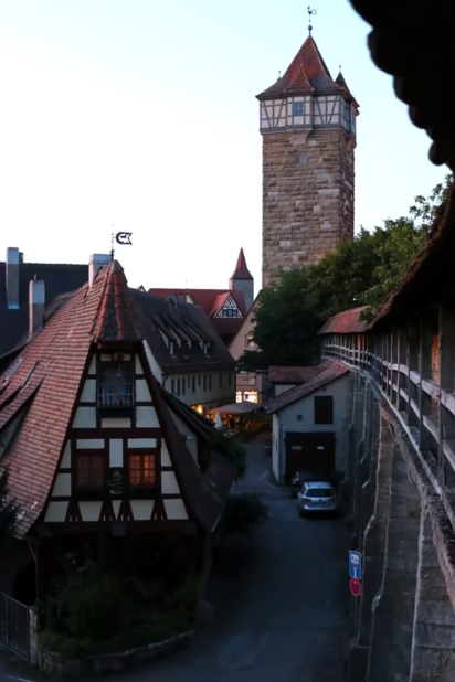
Walking on the sentry walk on the walls and ramparts of Rothenburg ob der Tauber is free and a top attraction when visiting the best romantic, wall-enclosed medieval town in Germany.

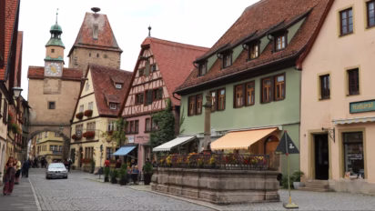
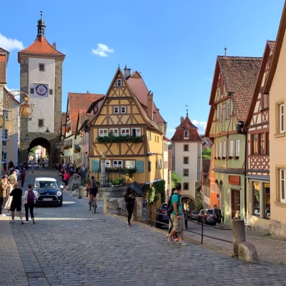
Romantic Rothenburg ob der Tauber, at the heart of the Romantische Straße tourist route in Germany, is famous for its beautifully preserved, picture-perfect medieval old town center, which is still surrounded by its defensive town wall. It is possible to appreciate the ramparts from outside the town but it is more fun to follow the sentry walk on the wall for fantastic views of the old town center, half-timbered houses, and the beautiful countryside. Access to the sentry walk is free and most of the walls are open year-round and at all times. Day-trip tours to Rothenburg are available from Frankfurt and Munich.
Ramparts of Rothenburg ob der Tauber

The medieval town center of Rothenburg ob der Tauber is still completely encircled by its town walls with over 40 towers and town gates still in place. Much of the walls are original from around 1400, with defenses strengthened until the mid-17th century. Following the Thirty Years’ War (1618-48), Rothenburg was too impoverished to dismantle the walls or update the town’s buildings according to newer fashions.
Rothenburg’s chocolate-box, picture-perfect medieval look only became popular again with artists and then tourists from the mid-19th century. Currently, Rothenburg attracts well over 2 million visitors per year. It is by far the most popular stop on the Romantic Road tourist route. Although most visitors are on day trips, few would regret sleeping over in this lovely old town.
It is possible to follow the sentry walk on the walls of Rothenburg around most of the town. The sentry walk is mostly covered, making it also a pleasant walk in rainy weather. Most of the walls are open at all times and year-round.
Town Walls of Rothenburg
The just over 3 km (2 miles) of town walls encircling Rothenburg were built in three main phases:
Rothenburg received town rights in 1172, which allowed the settlement next to an older castle to encircle itself with a defense wall. The original town was roughly circular (like Nördlingen, a bit further south on the Romantic Road).
The steep slopes on the western part of the town formed a natural defense but were topped by further walls. The Weißer Turm (White Tower) and über-romantic Markusturm (Markus Tower) with the Röderbogen (Röder Arch) still mark the outer limit of the city in around 1200. The total length of these first defensive walls was 1,400 m (1,530 yards).
In the second phase — late 14th century — the defense walls were moved outwards with the new ring away from the valley to mostly where the walls are today — the walls were now 2,400 m (2,624 yards). However, the southern limit was the Siebersturm (1385) just beyond the famous Plönlein square.
At this stage in history, Rothenburg with a population of 6,000, was one of the ten largest cities in Germany. (Definitions differ but irrespective of the way of counting or the political geography, it was one of the richest and most important cities in medieval Germany.)
The third and final phase added the southern tip from beyond the Plönlein to the Spitalbastei. This impressive figure-8 bastion was still strengthened during the Thirty Years’ War when Rothenburg was occupied several times.
By the mid-17th century, developments in military technology made town walls irrelevant and impoverished Rothenburg of little interest to attackers anyway. Then, as now, the total length of the wall amounted to 3,400 m (3,720 yards).
Access to the Walls of Rothenburg
Since the completion of the final building stage, the bird’s eye view shape of Rothenburg ob der Tauber resembles a keyhole, or a face (with a pointy nose) seen in side profile. Using the image of a side profile, it is possible to walk from the neck along the back of the head to the forehead, not along the face, but again from the chin to the neck.
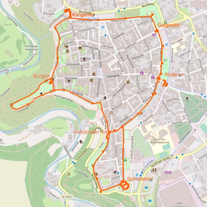
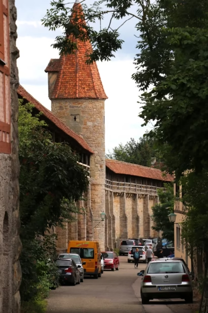
Using a map, it is possible to walk on the covered sentry walk all the way from the Spitalbastei (in the south) to the Klingenbastei (on the northwestern corner of the town) along the eastern and northern sides of the town (left and top on most maps).
The only significant parts of the walls of Rothenburg that are not accessible are on the west (left side of most maps) — from the Klingentor in the north to the Kobolzeller Tor (near the famous Plönlein) — and the small section at the south from Reichsstadthalle to the magnificent Spitalbastei.
Rothenburg ob der Tauber’s Ramparts and Walls
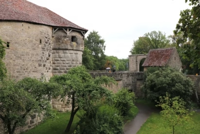
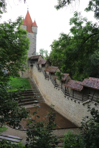
The medieval defense structures of Rothenburg ob der Tauber are among the most popular attractions of the town. Of the around 70 defense towers in operation in Rothenburg at the time of the Thirty Years’ War, 42 are still maintained in some form. The only one that may be climbed is the Röderturm (small charge).
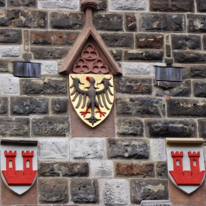
Most of the gates and towers display the shield with two red towers for Rothenburg ob der Tauber. The shield with the black eagle on a yellow background is for the Holy Roman Empire. It reminded visitors that they entered a Free Imperial City, which Rothenburg was from 1274 until it was absorbed by the Kingdom of Bavaria in 1802. (The double-headed eagle was only in use after 1433.)
Top Bastions and Town Gates in Rothenburg
Four of Rothenburg’s town gates with gate towers remain in use for motorized traffic. Several further smaller entrances in the walls are open to pedestrians.
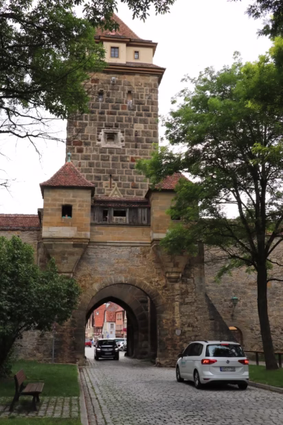
The most impressive part of the town defenses of Rothenburg ob der Tauber is the imposing Spitalbastei at the far southern tip of the town. This is the only town gate where the complete bastion survived mostly intact.
The Spital Bastion has double courtyards in the form of a figure 8. Seven gateways and upper walkways with embrasures survived. The bastion may be explored freely — the inside is dark at the best of times, so best explored before dusk. The interior is vast but the roof is fairly low, and the windows are small by design (form follows function). It was designed so horses could drag up cannons and supplies to the defenders.
Town Gate Towers
The Klingentor at the northern exit towards Detwang and Creglingen similarly has impressive fortifications, but these did not survive as intact as the Spitalbastei. An interesting part of the Klingenbastei is the Wolfgangskirche (1475). This church was built inside the bastion and was part of the town’s defense system. A huge water tank in the Klingenturm (1400) held the water supply for Rothenburg for over three centuries until 1910
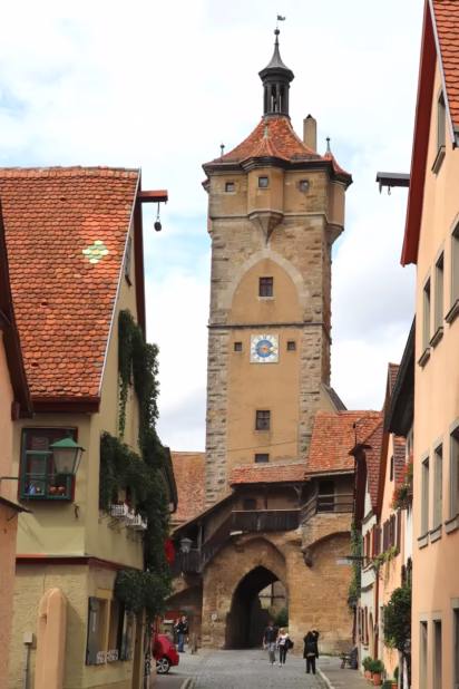
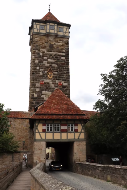
The Rödertor and Galgentor once had very mighty bastions, as these were at the side of Rothenburg, which had no steep slopes or other natural defenses. During the Thirty Years’ War, Tilly breached the walls here in 1631 and the French in 1645. The gate towers here survived but not that much of the original defense structures. Some of the forward gates at the Rödertor are still in place and worth exploring if unable to see the Spitalbastei or Klingentor. The Rödertor is the only defense tower that visitors may climb to the top (€2.50) but the Rathaus tower is more popular for aerial views.
The Galgentor is the only gate to Rothenburg open to drivers at busy times (and then only for those with hotel reservations or other permissions to drive into the old town center). Its real name is actually Würzburger Tor but as the gallows (Galgen) were nearby the impression they’ve left survived long after their use ceased in the mid-18th century. (When in Rothenburg, visit the very interesting Medieval Crime Museum for more on this and other criminal and legal history.) For this reason, the street inside the town leading from the Galgentor is the Galgengasse (Gallows Alley) while the street outside the gate is still Vorm Würzburger Tor (“in front of the Würzburg Gate”).
Smaller Town Gates
Two further gates gave access to the town but they are no longer open to motorized traffic:
Burgtor
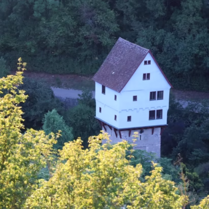
The Burgtor gives access to the Burggarten — a park with beautiful views of the old town, ramparts, Tauber Valley, Doppelbrücke, and the Topplerschlösschen.
The Burgtor was an important entrance to the town but is now cut off from motorized traffic links. Here, it is still possible to see not only the mask through which pitch could be poured onto attackers but also the mid-16th-century postern gate (a small door inside the main door). This so-called eye-of-the-needle door allowed individuals to enter the town one by one at night to prevent a surprise attack. Such admittance after dark required advanced permission from the town council — anyone arriving after sunset slept outside the town.

A glance from the Burggarten, where the original castle was, to the Tauber River in the valley 80 m below explains why it is Rothenburg ob der Tauber (Rothenburg Above the Tauber) and not Rothenburg an der Tauber (on the Tauber) in a similar fashion as for example Frankfurt am Main is “on the Main” and Frankfurt an der Oder is “on the Oder River”.
Kobolzeller Tor
The Kobolzeller Tor (1360) is less imposing but at the same time very interesting. The structures here are not as elaborate as those at the other gates, but it is possible to access the sentry walk here and see how the defenses worked. This smaller bastion had its own inner courtyard and four gates. The steep slope inside the courtyard made an attack difficult with defenses possible from the devil’s chancel above, as well as from the Kohlturm tower.
Also from here — just a few houses down from the crowded Plönlein — it is often very quiet and a pleasure to walk on the wall towards the southern part of the old town.
Where to Walk on the Ramparts in Rothenburg

While the Spitalbastei is clearly much more impressive than say the Galgentor, the difference for various sections of the wall is less pronounced. Simply walking along any section is fun and gives good views either of the old town center or the countryside, although the latter is less impressive away from the river.
Best Rothenburg Town Wall Walk
However, if given a free choice, after photographing the popular Plönlein, or actually the Siebersturm tower behind it, instead of heading back uphill to the crowded Market area, or through the gate to the southern part of the town, take the smaller road downhill to the right toward the Kobolzeller Tor.
Go up the stairs as soon as possible to see the defense structure of this gate from above. Then continue along the sentry walk as far south as possible — the Stöberleinsturm just after the amphitheater. This tower is the only one in Rothenburg to have preserved its original medieval roof and four corner turrets.
This section of the wall is often surprisingly quiet. However, the ramparts are interesting with several staircases in rapid succession to take the sentry walk down several levels. It offers great views of the valley but perhaps less so of the medieval city.
Rather than heading into town from the amphitheater, continue alongside the wall. Exit the town at the Sauturm (pig tower). Walk the short sections outside the wall to the impressive bulwark of Spitalbastei.
Sentry Walk from Spitalbastei to Klingentor

It is possible to walk on the sentry walk all the way from the Spitalbastei to the Klingentor — a total distance of 2.5 km (1.6 mi), all roof covered with several exit stairs if desired. Parts of the wall here were destroyed by aerial bombing on 31 March 1945 but were restored to their original condition. The name plaques here are of donors who originally helped to finance the restoration and of major contributors helping with the upkeep. The going rate is around €1,200 per m per year.
From this stretch of the wall, the old town views are the most interesting. The external views are not so much of the countryside but rather of the modern town and especially huge parking lots. The areas near the Rödertor and Klingentor are often busier due to the proximity to parking lots and bus stops. However, the old town views from here are superb.
A popular sight just south of the Rödertor is the Gerlachschmiede. This Instagrammable half-timbered house functioned as the smith shop until the mid-1960s.
Most of the air raid damage was in the northern parts of Rothenburg. The area near the northern walls between the Schrannenplatz parking area and the Galgentor is clearly less interesting than other parts of Rothenburg. However, the wall is generally a lot quieter than around the Rödertor.
The St-Jakobs-Kirche (St James) with the Holy Blood Altar by Tilman Riemenschneider is the dominant church towards the north of the town.
Walking Around Rothenburg ob der Tauber

It is of course also possible to walk around the outside of the walls of Rothenburg ob der Tauber. On the Tauber River side (west), it is even a highly recommended hike with beautiful views of the old town, ramparts, and the valley.
Best Views on the West Side of Rothebburg
On the west side, the town walls are mostly without a sentry walk, as the natural slope allowed for the defense wall to be much lower on the town side. It is often possible to walk right next to the wall inside the town and peek through the holes.
However, it is more interesting to walk on the outside of the town walls from the Klingentor to the Burggarten — where the original 12th-century castle was located. The small Topplerschlösschen (1388), on the opposite bank of the Tauber River, was the retreat of the famous Rothenburg medieval mayor Toppler. It is one of the most famous little castles in Germany but best seen from a distance. (The small structure is only open on special reservation.)
It is similarly a pleasant walk on the outside of the town from the Burggarten to the Kobolzeller Tor or even all the way to the Spitalbastei. These slopes are known as the Riviera and at times steep. Either follow the direct upper route or go down towards the Tauber River and the Doppelbrücke (Double Bridge) — a 14th-century bridge resembling a Roman viaduct that is still in use but not on the main road.
Hiking on the eastern side of the town gives good views of the ramparts, including the dry moat — wet moats are more a Hollywood fantasy, only the odd small castles, such as wonderful Schloss Mespelbrunn on the road to Frankfurt, originally had a true wet moat. Much of this area is park-like but also contains several large parking lots — walking on the sentry walk inside the walls is far more pleasant.
Other Wall-Encircled Towns in Bavaria

Rothenburg ob der Tauber is not the only wall-encircled town in Germany, it even has competition from several on the Romantic Road. At nearby Dinkelsbühl, all the town defense towers survived to the present but here it is necessary to walk around the town rather than on the walls. In Nördlingen, which is famously nearly perfectly round, it is possible to walk all the way around the town on the restored town walls.
These two towns are very pleasant to visit too and are often pleasantly quiet, but Rothenburg remains the medieval jewel in the crown of the Romantic Road. As most visitors to Rothenburg are day-trippers, hotel prices are surprisingly reasonable, making it a good option to stay the night and enjoy the much quieter town in the evening and early morning.
More on Rothenburg ob der Tauber
For more on the Rothenburg ob der Tauber and nearby sights on the Romantic Road:
- Top Sights on the Romantische Straße with Romantic Road Map
- Walk on the Ramparts and Sentry Walk on the Wall of Rothenburg
- Visit the St.-Jakobs-Kirche (St James Church) with the Tilman Riemenschneider Holy Blood Altar
- Visit the Medieval Crime Museum
- Visit the Wolfgang’s Church in the Klingenbastei
- See the Herrgottskirche with Tilman Riemenschneider Altar of the Virgin in nearby Creglingen
- Transportation to Rothenburg ob der Tauber – Driving or Take the Train
- Bus Day-Trip Tours are often available from Frankfurt or Munich.
- Hotel prices in Rothenburg are surprisingly reasonable, except over weekends.
- Save with the Bayern-Ticket on Train Transportation in Bavaria
- Get online quotations for taxis and airport shuttles from Frankfurt or Munich airports.